
|
 |
1996-1997 Winter Months Recapped
The more significant weather events occurring this winter included extreme cold in the Northern Plains states with minimum temperatures in the -20s and -30s on January 11, 12 and 13. An extreme low of -41 degrees Fahrenheit was noted at Havre, Mont., on January 11. Snowfall across the 48 contiguous states has been abundant in many areas. Many parts of the Midwest and Western states had snowfall totals at above normal levels. Marquette, Mich., exceeded 200 inches of snow for the season and was also about 30 inches ahead of last year’s snowfall. Out west, Seattle had a 14-inch snowfall just after Christmas. Ski resorts in the west also received above normal snowfall with a 130-inch snow base reported at Snowbird, Utah, in February. Conversely, snowfall along the East Coast through most of the winter was rather meager. Baltimore’s and Boston’s seasonal snowfalls through the first two-thirds of winter were much below their norms of 20 and 40 inches, respectively, and well below last year’s record or near record totals. However, late season snow activity was showing a tendency to bring these seasonal totals closer to normal levels. |
Air Routing International • Air Security International • Air Routing Group Card Services
Wilkens Weather Technologies • ARGIS
AiRMail • Current News and Press Releases
• Pilot Feedback
Meet Our Executives • Tell Us What You Think • Learn More About Us
Best experienced with
![]()
Click here to start.
![]()
 Alternate
periods of warmer and colder than normal temperatures
mixed with wet and dry weather brought an active and
progressive winter weather pattern to nearly all parts of
the United States during this 1996-1997 season. Invasions
of polar air masses into the United States varied as to
which part of the Northern states they entered first.
Sometimes entering the United States in the Pacific
Northwest and sometimes in the Northern Plains, these
masses at times even dropped directly into the Northeast.
Alternate
periods of warmer and colder than normal temperatures
mixed with wet and dry weather brought an active and
progressive winter weather pattern to nearly all parts of
the United States during this 1996-1997 season. Invasions
of polar air masses into the United States varied as to
which part of the Northern states they entered first.
Sometimes entering the United States in the Pacific
Northwest and sometimes in the Northern Plains, these
masses at times even dropped directly into the Northeast.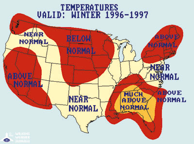 These
cold waves were counter-balanced by periods of near
normal or warmer than normal temperatures. Looking at
regional seasonal averages can see this. All regions of
the United States experienced seasonal average
temperature conditions only slightly above or slightly
below normal for the heating season. The United States as
a whole averaged near normal to slightly above normal
temperature readings.
These
cold waves were counter-balanced by periods of near
normal or warmer than normal temperatures. Looking at
regional seasonal averages can see this. All regions of
the United States experienced seasonal average
temperature conditions only slightly above or slightly
below normal for the heating season. The United States as
a whole averaged near normal to slightly above normal
temperature readings.