WWT Offers Early Preview for
Fall-Winter Season
 The
El Nino event from the summer of 1997 is expected to
continue through the autumn and winter seasons. An El
Nino event typically lasts from 15 to 18 months. This
pattern usually allows low pressure/cold front systems to
move across the southern half of the United States on a
regular basis. Another effect of the El Nino is to divert
the polar weather systems north of the United States on a
routine basis. Persistent or regular occurrences of
high-pressure (pacific origin) in the northern half of
the 48 contiguous states typically results from this. The
El Nino event from the summer of 1997 is expected to
continue through the autumn and winter seasons. An El
Nino event typically lasts from 15 to 18 months. This
pattern usually allows low pressure/cold front systems to
move across the southern half of the United States on a
regular basis. Another effect of the El Nino is to divert
the polar weather systems north of the United States on a
routine basis. Persistent or regular occurrences of
high-pressure (pacific origin) in the northern half of
the 48 contiguous states typically results from this.
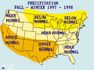
 The
frequency of these low pressure/cold front systems across
the Southern states is likely to accompany fewer surges
of freezing weather from the north. Also, fewer
snowstorms are presently indicated for the Northern
states next winter since we expect most of the very moist
air masses to remain in the south. We anticipate the snow
that does fall in the Plains states to melt by a greater
number of warming Chinook wind events than were noted
last winter. Finally, fewer outbreaks of arctic air into
the Central and Southern states are forecasted for next
winter than were noted this winter. The
frequency of these low pressure/cold front systems across
the Southern states is likely to accompany fewer surges
of freezing weather from the north. Also, fewer
snowstorms are presently indicated for the Northern
states next winter since we expect most of the very moist
air masses to remain in the south. We anticipate the snow
that does fall in the Plains states to melt by a greater
number of warming Chinook wind events than were noted
last winter. Finally, fewer outbreaks of arctic air into
the Central and Southern states are forecasted for next
winter than were noted this winter.
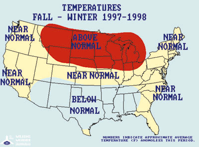
More
specifically, near normal to slightly above normal
temperature conditions may occur in the Central and
Northern Plains and Rocky Mountain states with only a few
colder than normal periods. Near to above normal
temperature averages are foreseen for the Midwest and the
Northeast. We predict cooler than normal conditions for
the Southern states with near normal temperature
conditions in the states west of the Rocky Mountains.
|