
|
 |
| Less Activity Predicted for the
1997 Hurricane Season
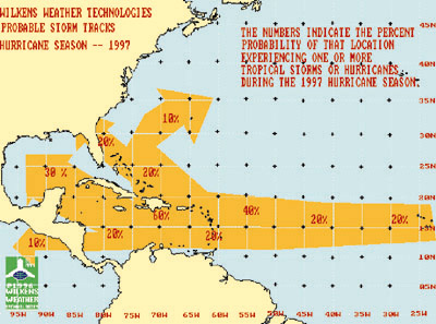
The sea surface temperatures across the tropical Atlantic, north of the equator, are still a degree or two warmer than normal. As a result, temperatures can still support the development of a few tropical storms and hurricanes in the area east of the Caribbean Sea and south of 20 degrees north latitude. The expected persistence of upper air high pressure this summer, over the western North Atlantic and the eastern United States, is likely to cause any disturbance that develops in this area to move more to the west compared to last season. This will make it more likely for the cities near the Gulf of Mexico to experience one of these storms during the summer. The East Coast, therefore, will less likely experience a tropical system this coming hurricane season. Overall, we expect the 1997 hurricane season to produce a few more tropical storms and hurricanes than normal (10), specifically across the Atlantic, Caribbean and Gulf of Mexico. We also anticipate two or three hurricanes to reach the more intense Saffir-Simpson categories of three or higher this summer and early autumn. This equates to a hurricane with maximum sustained winds of 111 mph or greater. Wilkens Weather Technologies specializes in trop-ical storm and hurricane tracking. To receive further information on these services, please call 800-503-5811 or visit our web site at www.wilkensweather.com. |
Air Routing International • Air Security International • Air Routing Group Card Services
Wilkens Weather Technologies • ARGIS
AiRMail • Current News and Press Releases
• Pilot Feedback
Meet Our Executives • Tell Us What You Think • Learn More About Us
Best experienced with
![]()
Click here to start.
![]()
 The anticipated El Nino event to take place this
summer will directly affect the 1997 hurricane season.
Since the conditions of El Nino typically produce an
environment in the Atlantic region tropics that are at
least somewhat unfavorable for the development of
tropical storms and hurricanes, we expect a decrease in
this activity compared to last year (see story on the
1997 summer season).
The anticipated El Nino event to take place this
summer will directly affect the 1997 hurricane season.
Since the conditions of El Nino typically produce an
environment in the Atlantic region tropics that are at
least somewhat unfavorable for the development of
tropical storms and hurricanes, we expect a decrease in
this activity compared to last year (see story on the
1997 summer season).