Worldwide Tropical Weather Support
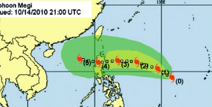
Tropical depression, tropical storm, hurricane (typhoon/cyclone) advisories and hurricane track/strike probability charts are provided every six hours for systems posing a threat to your area of interest. WWT provides tropical advisory support in all active basins in the Atlantic, Pacific, and Indian Oceans.
Daily tropical weather outlooks are also provided detailing conditions in the tropics that are conducive to tropical cyclone formation over the next three days.
WWT meteorologists are available 24 hours a day, 7 days a week to provide briefings regarding tropical disturbances that affect your operations.

Hurricane Animation & Range Rings, and G.I.S. Hurricane Tracking:
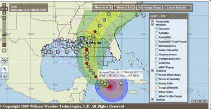
Available through WWT's custom GIS views, you can track the path of every storm in every tropical basin worldwide (based on your operating areas). This will give you access to various tropical weather model tracks, satellite data, site specific wind profiles, forecast location markers, buoy data, and many other layers overlaid on the tropical system's forecast track.
Range Rings allow you to graphically determine the distance of critical wind speeds and the eye of the storm from your location. Using the range ring feature, you can determine if and when the location of the storm requires you to implement the next step in your contingency plan. The storm track appears with rings around the eye of the hurricane. These rings represent various wind speeds, including gale and hurricane force winds. You add range rings around your site at distances dictated by your hurricane contingency plan or at distances you select. You animate the storm through its projected path to graphically depict the projected wind speeds at the crucial ranges you defined.

Hurricane Threat Assessments:
Upon request, hurricane threat assessments are prepared and include a thorough analysis of the current position of storm, distance of asset from the storm's current position, the direction and rate of advance of the storm, and other details. Most importantly WWT will analyze the most likely path (current forecast) vs. the worst likely path (path that would most negatively impact your location). Along each of the paths, WWT will analyze the time before arrival of various wind speeds, the duration of various levels of wind speed, and any other factors that will negatively impact your area (rainfall, storm surge, etc).

